Project Overview
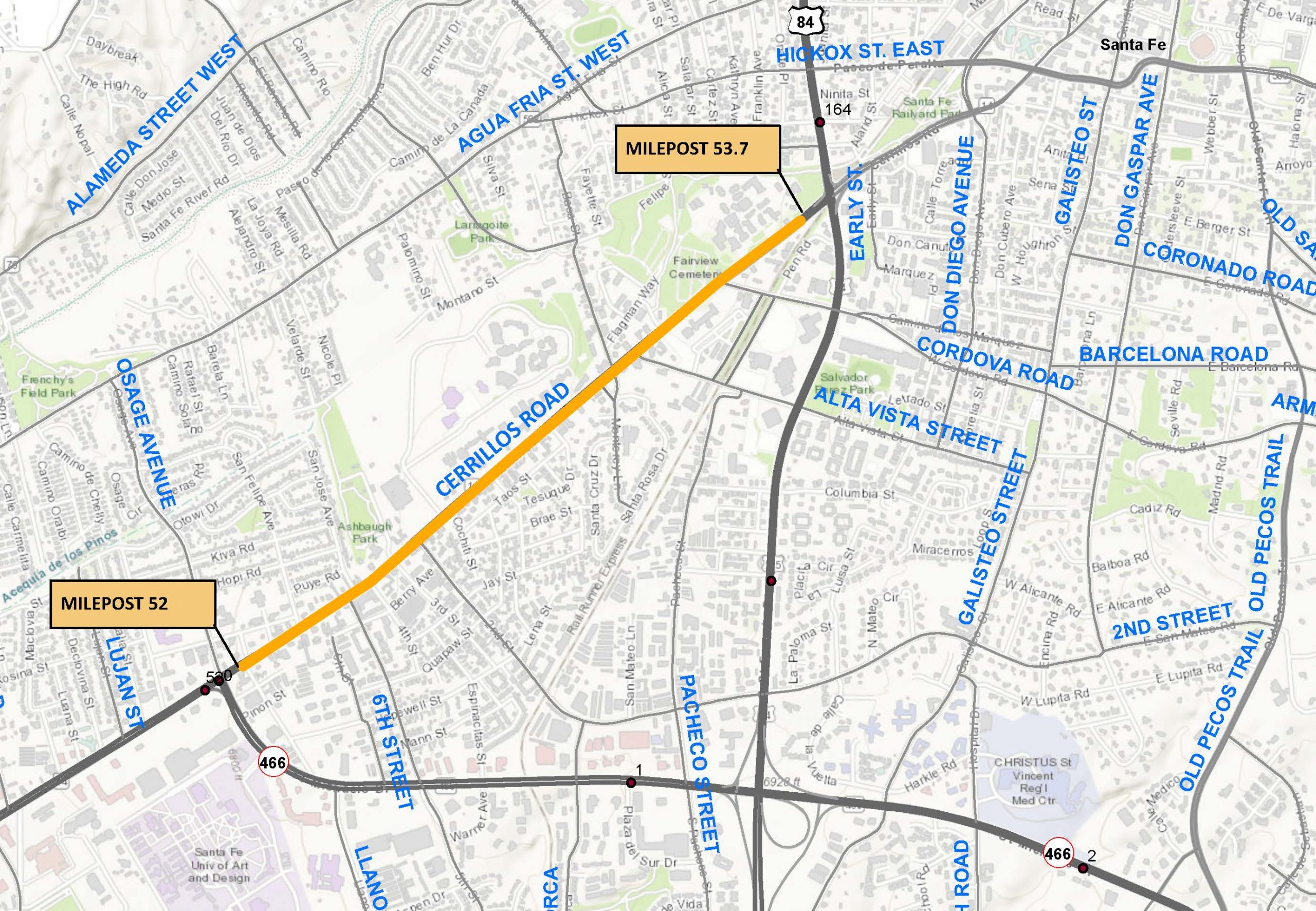
The NMDOT is developing design improvements for New Mexico Highway 14 otherwise known as Cerrillos Road within the City of Santa Fe between St. Michael’s (NM 466) and St. Francis Drive (US 84/285).
Cerrillos Road is a major thoroughfare in the Santa Fe metropolitan area transportation system. It is one of Santa Fe’s key transportation and land use corridors and one of the City’s most heavily traveled roadways. The corridor is multimodal with diverse land uses including small retail shops, schools, and large employers. Commuter mobility and local circulation are important functions for this segment of Cerrillos Road.
The current segment of Cerrillos Road represents the fourth and final segment to be upgraded from Interstate-25 at Beckner Road to St. Francis Drive in Santa Fe. The City of Santa Fe (CoSF) and the NMDOT have executed a road exchange agreement transferring the ownership and maintenance of Cerrillos Road along the project corridor to the CoSF once construction is completed. The previous Cerrillos Road phases have already been transferred to CoSF under this agreement. Therefore, while NMDOT is leading this study and project, the CoSF has been engaged and involved throughout the process. Within the study limits, Cerrillos Road is a four-lane facility built within a uniform 80-foot right-of-way that constrains opportunities to expand traffic capacity facilities. The selected improvements retain four (4) traffic lanes while balancing the multi-modal uses of the corridor and minimizing the acquisition of additional right-of-way and the resulting impacts on businesses and historic properties along the route.
Purpose and Need
The purpose of the improvements is to enhance mobility for vehicular, bicycle, and pedestrian travel, address physical deficiencies of the existing transportation facilities, and to better manage traffic flow. The need is demonstrated by the following:
- People and Goods Movement: Cerrillos Road is a regionally significant roadway corridor in Santa Fe used for all types of transportation purposes. Mobility in the corridor is key to efficient people and goods movement.
- Physical Deficiencies: Based on the existing conditions analysis of the project corridor, physical deficiencies were identified for the roadway including Americans with Disabilities Act (ADA)/PROWAG compliance issues at curb ramps and driveway crossings, areas within the project limits where sidewalks do not exist, mid-block pedestrian crossing spacings, and access issues particularly for adjacent business off-street parking areas in the corridor. The existing corridor is also deficient in storm drain infrastructure.
- Multi-Modal Corridor – Transit: The Santa Fe MPO Transit Master Plan notes that Cerrillos Road is a major transit corridor. Transit utilization along Cerrillos Road accounts for approximately 33 percent of total transit service hours and well over 50 percent of internal ridership in the area. Enhancements to transit services is being investigated as part of this project.
Figure 1. Project limits extend from St. Michaels Drive to St. Francis Drive. Intersection improvements at St. Michaels and St. Francis are not part of this project (click to enlarge the image).
Next Steps
The Phase I-A/B Study was completed in September 2022 under Control Number S100680. Design development (Phase I-D and Phase II) is underway for Cerrillos Road and the NMDOT Campus. The environmental documentation and design phases are anticipated to be completed in Fall/Winter of 2024. Construction funding identified under Control Number S100681 for the proposed roadway improvements has been secured and the start of construction is expected to occur in early 2025. Construction funding identified under Control Number S100682 for the NMDOT Campus improvements has been secured and the start of construction is expected to occur in Fall/Winter 2024.
As the delivery of the Cerrillos Road project progresses, the public and stakeholders will continue to be engaged by the project team. Property owner interviews are being coordinated with landowners where additional right-of-way is necessary. The CoSF and Santa Fe Metropolitan Planning Organization (SFMPO) staff will continue to be engaged and help guide delivery of the project. Meetings with the Santa Fe Indian School, the New Mexico School for the Deaf, and businesses along the project corridor will continue to be held to coordinate project-specific details. Pertinent project background information will continue to be shared on the NMDOT project website.
County
Santa Fe
District
District 5
Status
Study and Design
Contact
Manuel Maestas
Project Development Engineer
(505) 629-7251
Manuelito.Maestas@dot.nm.gov
Public Involvement
Public and Agency Coordination
The Phase IA/B Study process included agency and stakeholder coordination to identify needs and key issues so they could be addressed in the collaborative development of the proposed improvements. Coordination was undertaken with other federal, state, and local agencies with jurisdiction and/or responsibility for lands and resources within the study area as well as members of the local community. The study team held public involvement meetings with the structure and content of a virtual meeting platform scaled to the context of the local community and the purpose and need. In addition, the study team also held a business-targeted public meeting to seek feedback from the businesses along the study corridor. Extensive feedback was received from the community with common concerns centered around traffic safety and congestion, and bicycle and pedestrian safety and accommodations.
Study Working Group
Due to the extensive public feedback received, a Working Group consisting of NMDOT, CoSF, and SFMPO staff was formed to guide the study efforts and develop and identify the selected alternatives. Please visit the Project Resources below.
For More Information
Visit the Public Involvement page to review available public involvement resources.
Project Resources
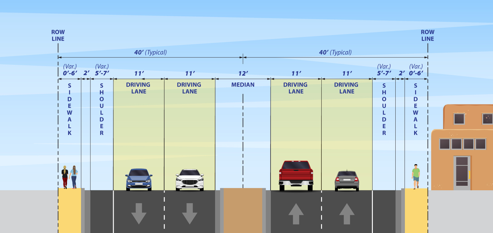
Cerrillos Road is classified as a principal arterial between St. Michaels and St. Francis Drive, the posted speed limit is thirty-five miles per hour (35 mph), and the daily traffic volumes approach 30,000 vehicles per day. Cerrillos Road has four 11-ft wide travel lanes, 12-ft raised medians, variable shoulder widths, and intermittent sidewalks as shown in Exhibit 1. The existing right-of-way is 80 feet wide (see map below).
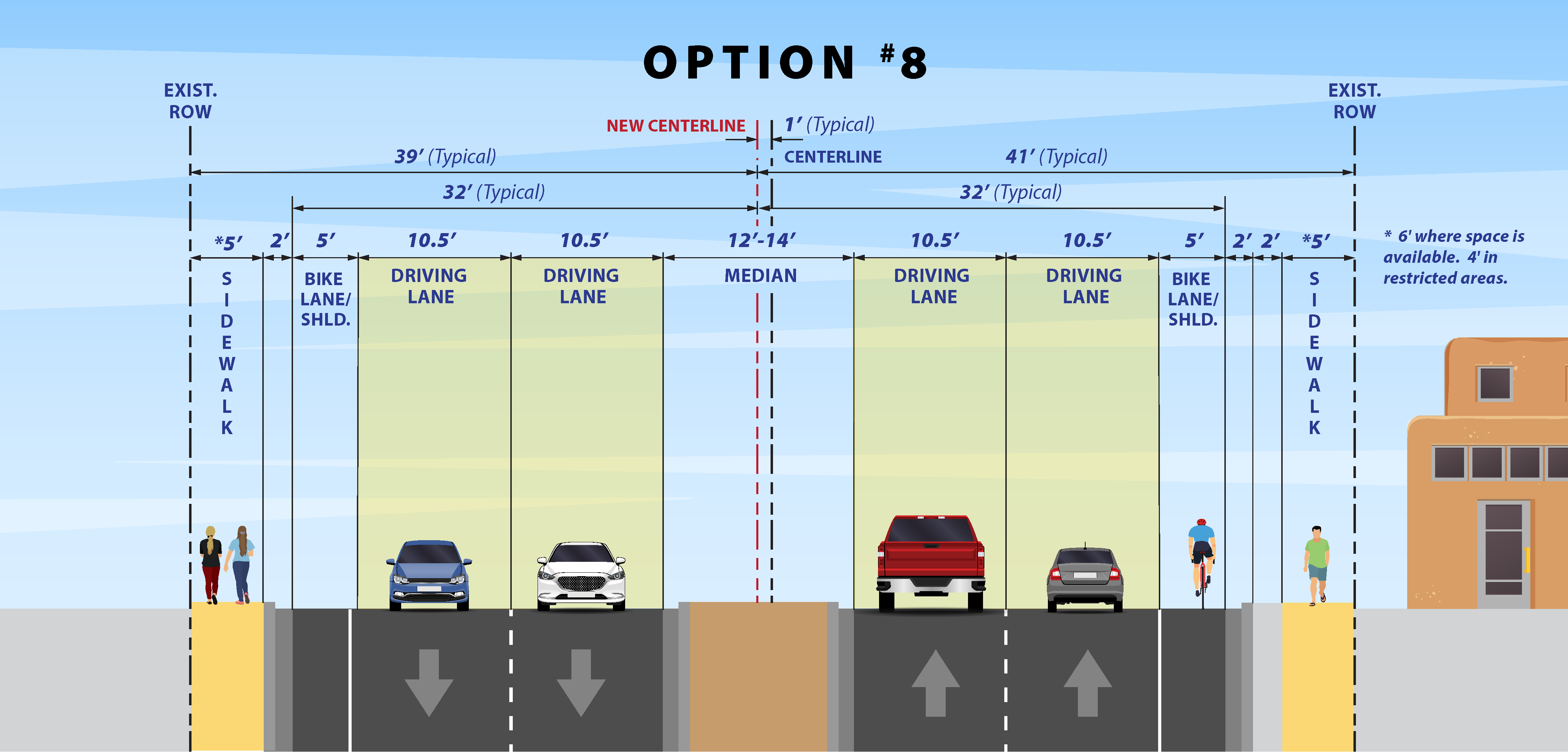
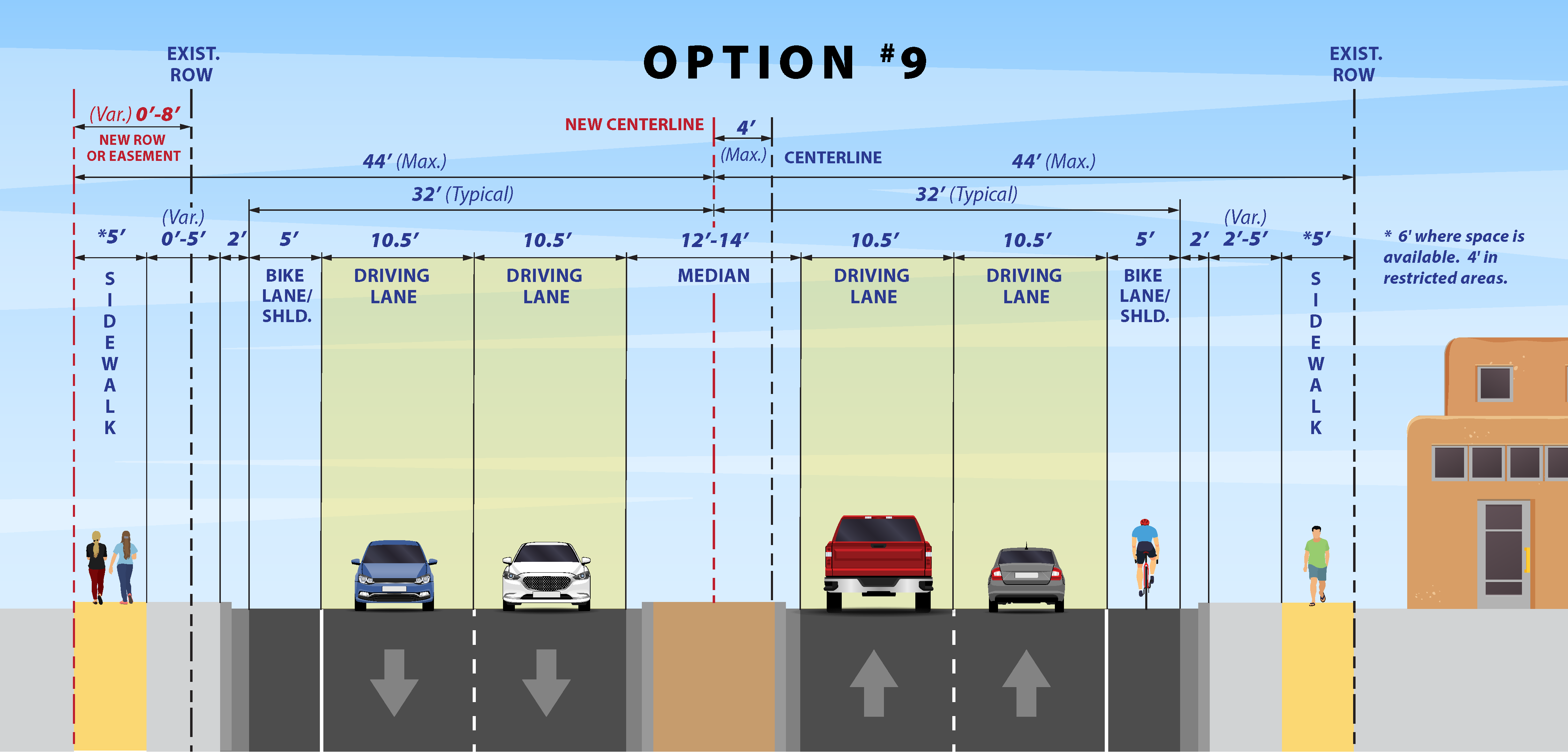
The selected alternatives shown in Exhibit 2. Option 8 and Exhibit 3. Option 9 advanced from the study phase into design development. These alternatives retain four (4) traffic lanes while balancing the multi-modal uses of the corridor and minimizing the acquisition of additional right-of-way and the resulting impacts on businesses and historic properties along the route. The selected alternatives have the following elements:
- 12 to 14-foot center medians
- 10.5 foot driving lanes
- 5-foot bike lane/shoulders
- 5-foot sidewalks with 0 to 5-foot buffers between curb and sidewalk
Additional location-specific improvements will also be included based on field conditions.
Phase I A/B Study
Phase I A/B Alignment Study Report – FINAL
Phase I A/B Chpt 4 Public Involvement Appendix
Phase I A Appendix
Phase I B Appendix
Traffic Signal Warrant Study – Cerrillos Road & Railfan Road/NMDOT Driveway Intersection, November 2022
Additional Resources
Existing Right-of-Way Map
Selected Typical Section – Option #8
Selected Typical Section – Option #9
30% Design Roll Plot – DESIGN IS SUBJECT TO CHANGE (*not for construction)
Preliminary Transit and Landscape Concepts


